Introducing the New Trail Finder Website - Finding a Hike Has Never Been Easier!
 We all have those afternoons and weekends where we want to go out and get into the woods, but we don’t feel like hiking our usual spots and aren’t sure where to head. Lucky for you, the Vermont Department of Forests, Parks, and Recreation has teamed up with the Upper Valley Trails Alliance (UVTA) and the Vermont Geographic Information Systems (GIS) Community to help you solve that problem! We are very proud to announce our new Trail Finder website, just in time for National Trails Day on June 6th.
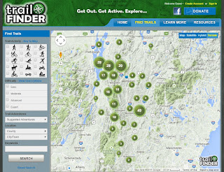
How does it help you? Trail Finder (www.trailfinder.info) is basically a search engine for trails in our region that combines interactive trail maps and descriptive details that enable you to search not only by town, but also by hiking difficulty, trail activity (mountain biking, snowshoeing, etc) or keyword. It presents you with a list sorted by relevance to your search, and you can see all of the trails’ stats easily as you scroll: activities offered, location, difficulty, and length. If you are interested in one, click “View Trail” to check out a detailed description, map, weather forecast, and directions to the trailhead.
 Thanks primarily to funding from the Vermont Recreation Trail Program, the Trail Finder website will provide visitors and residents with a free resource that they can both utilize and contribute to—we are actively seeking pictures, comments, and trail suggestions from our users! You will need to create a free account in order to make comments, and if you are interested in becoming a trail manager or would like to see a trail on the site, please contact our Recreation Coordinator Jessica Savage at jessica.savage@state.vt.us.
Some of the highlighted features of Trail Finder include:
 Geolocation: Access our mobile site on your smart phone and see yourself on the map! You can also download trails and maps into your GPS unit or view them on Google Earth.
See Nearby Trails: We’re making it easy to expand your experience or plan a bigger trip—associated trails will be linked to your trail selections so you’ll have more options at your fingertips.
More Photos: We’re trying to get slideshows up of all the trails so that you’ll know what to expect, and don’t forget to send us your own trail pictures if you notice a trail has no photographs yet.
Improved Communication: Encounter a fallen tree that blocks a trail? Have suggestions about your trail experience? Contact information is available for each trail, which enables hikers to get in touch with trail managers even faster.
Enhanced Search Capabilities: Looking for trails that allow motorized vehicles? Pet friendly hikes? Hikes that end up at fire towers? We’ve got you covered.
Having fun in the great outdoors just got a whole lot easier…just spend a few minutes searching, find your perfect trail, and we’ll see you out there. Happy Trail Finding!
By Carlie Timbie
Vermont State Parks

.jpg)
.jpg)
Love this. An app would be fantastic!
ReplyDeleteGreat!!!
ReplyDelete