Fall Hikes At Vermont State Parks: Part 1, Northern VT
 |
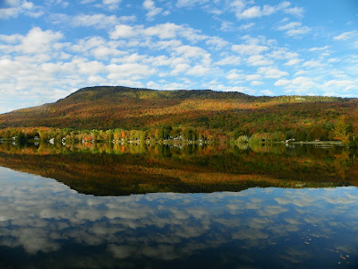
| View of Elmore in fall |
Mt. Philo State Park in Charlotte
Summit Trail
Campground Trail
This park is one of the
most popular hikes in the Champlain Valley, with easy access to Burlington, and
stellar views of Lake Champlain from the top in any season. A good spot to take
your friends from out of town!
Camel’s Hump State Park,
Duxbury VT
Burrows Trail
Probably the most iconic mountain in Vermont. Several trails lead
to the top from moderate to strenuous. If you want a less difficult hike, the
Camel’s Hump View Trail is .08 miles along a wide, flat path, universally
accessible, and with pretty views of the summit.
Camel's Hump trail map:
Brighton State Park, Island
Pond VT
Northeast Kingdom Nature
Trail
For those looking for a short hike that is a good choice for
families, try the nature trail at Brighton State Park. This is an easy hike and
also a good way to learn about the surrounding environment of the Northeast
Kingdom, which is known for putting on an impressive foliage display each fall.
 |
| Enjoying the scenery at Underhill State Park |
Trail map here:
New Discovery State Park,
Marshfield VT
Owl’s Head Trail
The Owl’s Head Trail, with its’ iconic view west towards Kettle
Pond and the mountains beyond is the most well-known, and another good spot to
take out-of-town visitors. Groton State Forest also has a network of over 40 more
miles of trails, so after you hike Owl’s Head, make some time to explore more
of the forest.
Elmore State Park, Lake
Elmore VT
Fire Tower & Ridge
Trails
Mountain Brook Nature Trail
From the trailhead parking lot, two summit trails take you up Elmore
Mountain, which has views overlooking Lake Elmore, the Worcester Range and
Mount Mansfield to the west from the fire tower. A half-mile nature trail
starts from the same place and loops around through the forest, past several
species of maples.
Underhill State Park,
Underhill VT
Smugglers’ Notch State Park,
Stowe VT
Mount Mansfield is the tallest peak in Vermont, and Smugglers’
Notch and Underhill offer access from both sites of the mountain.
Map of Mount Mansfield Trails:

.jpg)
.jpg)
Comments
Post a Comment
Feel free to let us know what you think.