Wednesday, February 29, 2012

But Wait, There's More! Question and Answer Part II of Camel's Hump History


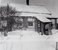
The former Will Monroe house
On a recent blog post, "A Question Asked and Answered: Some Really Interesting Camel's Hump History",we shared a question asked by a park visitor about the history of Camel's Hump, and a really interesting answer from Stewardship Forester, Gary Sawyer.

Well, Doug, our park visitor, came back with a few more questions for Gary, and here's how it went:

Doug: My sister recently found a hand-written journal kept by our father when he and two other lads from Montpelier hiked the Long Trail from Duxbury to Rutland in August of 1921. Here is an excerpt of his first day account:

"Brock, Lindsay and Jones left Montpelier at 3:00 P.M. Sunday with every expectation of rain. Arrived the Callahans 4:00 P.M. Packs weighed about 35 lbs. each. The first half mile was somewhat of a torture to our untrained muscles. Stopped about 6:30 at the Boy Scout camp for supper. The rest of the way to the top was so steep that our noses scraped on the boulders. Most of the trail was composed of a running brook which thoroughly soaked our feet. We reached the top at 8:00 P.M.,  five hours after leaving Montpelier. This was called good time as we came up over the old trail. R. Kate was in charge of the huts and he made us some excellent coffee and we had a most delicious meal. By the use of nine blankets we were able to keep fairly warm. Covered 4 miles."


I assume that 'R. Kate' was a GMC caretaker at the 'hut clearing'. Is that correct? Where was the Boy Scout Camp? Is it still there or are there any remains?
A section of one of the old maps
I have some weather record data from the VT State Climatologist for August 1921 for Morrisville and Middlebury. Can you tell me, based on your experience, what the normal high and low temperature differentials are for the valley floor at Waterbury versus your summit?

Gary's answer: Thanks for your questions, Doug. I looked back and found even more from surveys from 1917 - 1919 which helped to produce maps showing old trails and buildings. These maps (a portion shown to the right) and corresponding journal entries helped to fill in some blanks from the past.

On the map, there is a label for "Callahan’s" which refers to a house that used to be at the base of what is now called the Monroe Trail. This house was occupied by Will Monroe and his sister Katherine after the Callahans moved out and was removed in the early 1970s due to its poor condition. On that same side of the mountain in the early part of the 20th century, two main trails lead up to the summit, the Old Callahan and the New Callahan.

Old fashioned winter camping
The New Callahan at some point became the Forestry Trail before more recently being re-named as the Monroe Trail. The Old Callahan trail, which was closed due to erosion in the late 1970s, was a more direct route to the summit area. If you stand at the base of the Monroe Trail (New Callahan) today and look upslope, the old trail was to the right of the Monroe Trail. This is undoubtedly the route your father took, and in places is still findable. Paralleling this old trail was a phone line, pieces of which a very observant person can still find attached to old trees. This led to a phone located at the Hut Clearing, the junction of today’s Long/Monroe/Burrows Trails.

One of the old cabins
Another old building on the map, the Boy Scout cabin, was a little more than ¾ of the way up the old trail, probably near where it crossed today's Alpine Trail. A journal note describes the trail as being steep and having a running brook. I hiked this route back in the late 1960s as a Boy Scout, and again after I joined FPR in the late 1970s. It's a wonderful trail to hike with beautiful vistas. The trail is under consideration for re-opening someday. It would take a good bit of work and some route adjustments before opening.

Another feature referred to on the old maps, were huts which were probably the ones at the Hut Clearing run by the Camel’s Hump Club, not the Green Mountain Club. The map indicates that at the huts was a phone, a store, and a caretaker. There are no remains of the huts in the clearing or the Boy Scout camp - at least none that has been found yet!


First forest fire lookout in Vermont
 Finally, an answer on your temperatures question. Today, as well as 100 years ago, the temperature on the mountain ranges quite a bit. It can drop 5 degrees per 1000’ elevation change, so from Waterbury to the summit of Camel’s Hump the ambient temperature could be about 20 degrees less, plus wind chill. Winds are normally a bit stronger up there too, so if you are venturing out to explore new or old trails on Camel's Hump be sure to dress warmly and take all the provisions you will need for the journey.

If you have some history on a state park or state land, please share it with us. You can email your stories to parks@state.vt.us or call us 888-409-7579.

Bookmark and Share

Tuesday, February 21, 2012

Smugglers' Notch State Park to be featured on The Travel Channel's new "Park Secrets" Show

A few from the park of the
surrounding mountains
A new show, "Park Secrets", airing this summer on the Travel Channel brought Lusid Media including Jillian Cohen, the producer for the show, and her crew to Smugglers' Notch State Park on February 1st. The show uncovers "Park Secrets" and showcases a handful of hidden parks across the country and explores why they are so special. Regional Park Manager, Susan Bulmer, spent the morning with Jillian, discussing one of Vermont's hidden gems tucked in the green mountains near Stowe and what folks enjoy most about the park.
Susan speaks to the film crew

Smugglers’ Notch State Park is a little more 'hidden' in the winter months as part of the mountain road closes until the snow is gone, but that doesn't seem to stop many people from seeking it out and enjoying what the park has to offer. Ice climbing, skiing, snowboarding, and snowshoeing are popular sports in and around the park. In fact, two ice climbers from the Mad River Valley were gearing up to go ice climbing during the filming, so Jillian had a chance to interview them about their experiences ice climbing in the Notch. For more on trails click here.

In addition to sports, it is off-season camping in Smugglers' Notch this time of year, but many prefer to stay in The Stone Hut (located nearby) which is open only during the winter season. This 12-bunk hut is the perfect place to warm up with some hot cocoa after a day of sking, climbing, or snowshoeing. For more information, click here.

Whether you are an active adventuresome person or more of a cozy camping enthusiast, visit the secrets of Smugglers' Notch this winter. The short film segement featuring Smugglers’ Notch will also include Laughing Moon Chocolates and Trapp Family Lodge. Keep an eye out for it sometime in July or August, until then keep enjoying the winter!


Bookmark and Share

Tuesday, February 7, 2012

Sunday, Feb. 19 Trek to Knight Island State Park! Plus, Other Fun Events This Weekend and Next!

The bike on ice race begins!
(Frozen Regatta scheduled for Feb. 18)
The only time of year when skiing, walking, skating, and sledding can be done on Lake Champlain is now! As part of the Great Ice in Grand Isle celebration, Vermont State Parks is encouraging folks to get out on the ice by hosting a 'Trek to Knight Island' on Sunday, Feb. 19th from 11:00AM - 4:00PM.

Grab your skates, skis, snowshoes or sleds and make the trek to Knight Island State Park – which is only accessible by boat during the summer.

The hike to Knight Island is about 4 miles round trip leaving from North Hero’s welcome dock. Once there, you can also explore the island's trails before warming up at the rustic ranger station where you can enjoy hot beverages and island lore, compliments of Park Ranger Jim Putnam.

A family trekking across the ice to Knight Island State Park
(scheduled for Feb. 19)

Knight Island, acquired by the state in 1990, is one of three neighboring island parks in Lake Champlain’s “inland sea.” The others are Burton and Woods Island State Parks. This 185-acre island is a mile long and nearly a half-mile wide. The park includes all but 10-plus acres of private land on the island's southern tip. There’s no power on the island, so everything runs on wood or propane.

In addition to the 'Trek', check out the other celebration activities including a chili cook-off, a bonfire, hockey, dancing, skating, films, ice-golf, dog sledding and more! For a full listing of the details for this weekend and next, visit http://www.vtstateparks.com/htm/events.htm.


View from Grand Isle across Lake Champlain to NY
The Great Ice in Grand Isle's schedule is weather dependent. For updates call the Lake Champlain Islands Chamber of Commerce at 802-372-8400 or Hero’s Welcome General Store at 802-372-4161. You can also visit http://www.champlainislands.com/, http://www.heroswelcome.com/, http://www.northherohouse.com/. Also, there's free parking in North Hero Village.

See you there this weekend!

Bookmark and Share